Land Exchange
A Message from former Chairwoman Tanya Lewis
The Yavapai-Apache Nation’s story is one of strength and survival, with an acknowledgment of our past coinciding with an enthusiastic outlook for our future. We are resilient people. After enduring removal from our home, oppression, and lack of civil and voting rights, we are here today and continue working to make a home for our people while continuing to protect the natural resources of our tribal homelands.
Land is the foundation of almost all economic and social activity of the Yavapai-Apache Nation. It is necessary for housing, commercial activity, infrastructure, water resources, agriculture, industrial development, open spaces, and countless other uses. In acknowledgment of the past removal of our people from our homelands, the preamble to the Yavapai-Apache Nation’s Constitution recognizes that among the responsibilities of the Nation is to “acquire additional lands for the benefit of the Tribe.”
Our Nation’s reservation lands are currently comprised of just over 1,800 acres spread out across the communities of Middle Verde, Lower Verde, Tunlii, Rimrock, and Clarkdale. For decades, this relatively small land base has been inadequate for our growing population’s economic and social needs. It is why in the early 1990s, our Nation began acquiring privately owned parcels of land within various National Forests in Arizona. The hope has always been to exchange those lands for Forest Service lands adjacent to the Nation’s Reservation lands.
While the Nation has made significant progress, our need for additional lands for housing and other homeland purposes remains unfulfilled. Just look at the more than 150 families who are currently on the Nation’s waiting list for new homes. The Nation’s land exchange, which you will read more about below, has the potential to increase the size of our Reservation to almost 5,000 acres if all Forest Service lands in the exchange proposal are acquired. This is a critical step in our history and vital to the Nation’s cultural and economic recovery and future prosperity. Click here to read “A Brief History of the Yavapai-Apache Nation and its Lands.”
Yavapai Apache Land Exchange Public Meeting Handouts and poster
| Documents | Link |
| Press Release: Forest Service and Yavapai-Apache Nation Finalize Land Exchange | Click here |
| Open House Handouts | Click here |
| Land Exchange, Trust Acquisition, and NEPA Process: Timeline Yavapai-Apache Nation Federal Land Exchange and Acquisition of Lands into Trust Status Draft Environmental Assessment | Click here |
| Federal Parcels: Yavapai-Apache Nation Federal Land Exchange and Acquisition of Lands into Trust Status Draft Environmental Assessment | Click here |
| Land Exchange, Trust Acquisition, and NEPA Process Timeline | Click here |
Land Exchange
The Yavapai-Apache Nation Federal Land Exchange involves the proposed exchange of about 4,782 acres of largely unspoiled National Forest inholdings owned by the Yavapai-Apache Nation to the United States Forest Service. The Nation’s exchange lands include six parcels located in four National Forests – Prescott, Coconino, Kaibab, and Apache Sitgreaves – all of which are totally, or in two cases mostly, surrounded by National Forest lands. In exchange, the Nation would receive about 3,201 acres of federal land, most of which is urban interface land and nearly all of which is contiguous to the Nation’s existing Reservation lands near Camp Verde, Arizona. Over time with the growth of local communities, including the Nation, these federal lands have lost much of their character as wildland forests. Two of the smaller parcels are isolated from the main body of National Forest lands, making Forest Service management difficult. While both the urban interface and the isolated parcels present challenging management issues for the Forest Service, the proposed exchange lessens those challenges and provides for better management of Federal lands.
The Forest Service has tentatively determined that the proposed exchange will serve the public interest and that it is in the interests of the United States and the Yavapai-Apache Nation. Additional information about the public involvement and disclosure process and Environmental Assessment for this proposal can be located here.
What is a land exchange?
The laws of the United States authorize the Forest Service to carry out land exchanges to meet the public’s interest in consolidating fragmented inholdings within Forest Service boundaries, thereby achieving more effective overall land management. Under federal land exchange regulations, individuals, corporations, or other entities, including Indian Tribes, who own privately held parcels of land within Forest service boundaries, can propose an exchange of such private “inholdings” to the Forest Service in exchange for other Forest Service lands identified by the proponent. Federal regulations establish a process under which such exchanges are carried out. Among other things, the regulations require an analysis of the environmental effects of the exchange, an appraisal of the relative values of the lands being exchanged, and detailed documentation of title to the lands. When the exchange is ready to close, the Forest Service and the proponent of the exchange transfer their respective legal interests in the lands by deed to each other, and the exchange is complete.
What lands are being exchanged?
Federal Forest Service Lands: 3,201acres
- Montezuma Parcels (NF1-NF4) – Parcel Description (Link), Photos (Link), and Map (PDF)
- Lower 260 (NF5) Parcel Description (Link), Photos (Link), and Map (PDF)
- Upper 260 Parcels (NF6) – Parcel Description (Link), Photos (Link), and Map (PDF)
- Middle Verde Parcels (NF7-NF9) – Parcel Description (Link), Photos (Link), and Map (PDF)
- Cedar Ridge Parcel (NF10) – Parcel Description (Link), Photos (Link), and Map (PDF)
Non-Federal Yavapai-Apache Nation fee-owned inholding lands: 4,782 acres
- Red Mountain at Yavapai Ranch Six Sections Parcel (YAN1) – Parcel Description (Link), Photos (Link), and Map (PDF)
- Johnston Ranch Parcel (YAN2) – Parcel Description (Link), Photos (Link), and Map (PDF)
- Pinedale Parcel (YAN3) – Parcel Description (Link), Photos (Link), and Map (PDF)
- Laurel Leaf Parcel (YAN4) – Parcel Description (Link), Photos (Link), and Map (PDF)
- Heber Parcel (YAN 5) – Parcel Description (Link), Photos (Link), and Map (PDF)
- Williams Parcel (YAN 6) – Parcel Description (Link), Photos (Link), and Map (PDF)
What does the public get in return?
Land exchange regulations require the Secretary of Agriculture, or a delegated representative, to determine that the proposed exchange is in the “public interest.” In making this determination, the regulations require an examination of various factors, including achieving better management of federal lands, meeting the needs of state and local residents and their economies, and securing essential objectives such as protection of fish and wildlife habitat, cultural resources, watersheds, and expansion of communities. The Land exchange will provide many important benefits not only to the Nation and the United States but also to the non-Indian communities within the Verde Valley, as well as the numerous public constituencies who look to public lands as a national treasure.
For example, one of the most valuable parcels of the Nation’s exchange includes six sections of land, a total of 3,896 acres, within the historic Yavapai Ranch located in Chino Valley in the upper Verde River watershed. Transfer of these lands alone to the United States will provide innumerable benefits not only to the Forest Service and the natural environment, but also to the public and the public interest. Importantly, the headwaters of the Verde River arise in the area encompassed by Chino Valley. Protection of the Verde River as a flowing river begins with protecting these headwaters. The economic and cultural future of the Nation, as well as the communities throughout the Verde Valley, like Clarkdale, Cottonwood, and Camp Verde, depends on a healthy and vibrant flowing Verde River. The transfer of the Nation’s six sections of land within the Upper-Verde watershed, together with ongoing Forest Service land consolidation efforts adjacent to these lands, will make a significant contribution to protecting the Verde River as an essential asset for all Verde Valley communities.
In addition, the transfer of these upper-Verde River watershed lands will provide improved recreational access for Arizona’s hunters and outdoor recreationists, as well as enhanced protections for the wildlife that depend on the lands for habitat and annual migration corridors. These lands provide priceless habitat for deer, elk, bear, javelina, antelope, small mammals, and innumerable birds and reptiles, all of which depend on a stable habitat for their existence. The Nation’s six sections provide important public access points to the adjacent Juniper Mesa Wilderness Area and to the thousands of acres of adjacent forest, woodlands, and grasslands that are treasured by outdoor recreation enthusiasts and hunters. While Yavapai Ranch lands are currently open to the public, if sold for development, that access could be lost forever.
The Yavapai Ranch example illustrates the value of just one of the Nation’s six parcels being offered as part of the exchange. In fact, each of the Nation’s six exchange parcels brings its own unique characteristics to the exchange for the benefit of the Forest Service and the public. The Nation’s 315-acres of land at the Williams parcel, located just southeast of the Town of Williams, is another example of the significant value the Nation brings to the exchange. This parcel is adjacent to the popular recreation area at Dogtown Lake and remains in substantially the same pristine condition that existed at the time of its original patent from the United States in 1905. For more than one-hundred years, this land was the headquarters of Arizona’s historic Pouquette Sheep Company. Importantly, this parcel is the core of the local watershed that provides the drinking water supply for the Town of Williams. The Town’s principal water well is located within the boundaries of the Nation’s parcel.
The exchange will have significant positive benefits for both the Nation and the local community of Camp Verde. In June 2022, the respective Councils of the Nation and the Town approved and signed an Intergovernmental Agreement (IGA). The IGA describes how the Nation will manage the acquired lands upon completion of the exchange. Under the IGA, the Nation and Camp Verde will share their respective future development plans and consult with each other on any identified concerns. Importantly, the IGA also includes provisions addressing a tax-sharing arrangement between the Nation and the Town. The Town will benefit from any non-Nation development on the new lands and will also receive a portion of the taxes generated by the Nation within a designated portion of the new lands. Negotiation of the IGA occurred over several years and required a public process led by the Town of Camp Verde for its community members and by the Nation for its community members.
How is the land valued?
The US Code of Federal Regulations Title 36, Chapter II, Part 254.12 authorizes the Forest Service to exchange lands “which are of approximately equal value.” The Regulations require that an independent 3rd-party appraiser be retained to appraise the Nation’s privately owned inholdings and the federal parcels proposed for exchange to determine the relative market values of the parcels. The regulations authorize an equalization of the values by either removing parcels from the exchange or allowing the proponent to contribute cash to bring the values within the “equal value” standard. The Nation and the Forest Service have prepared an Equalization Plan (the “Plan”) based on the current configuration of the proposed exchange. The Plan allows modifications to the proposed exchange by adding or removing either Federal or Non-Federal land to achieve equalization. The Plan is subject to amendments as the exchange develops.
What is the cultural significance of these lands?
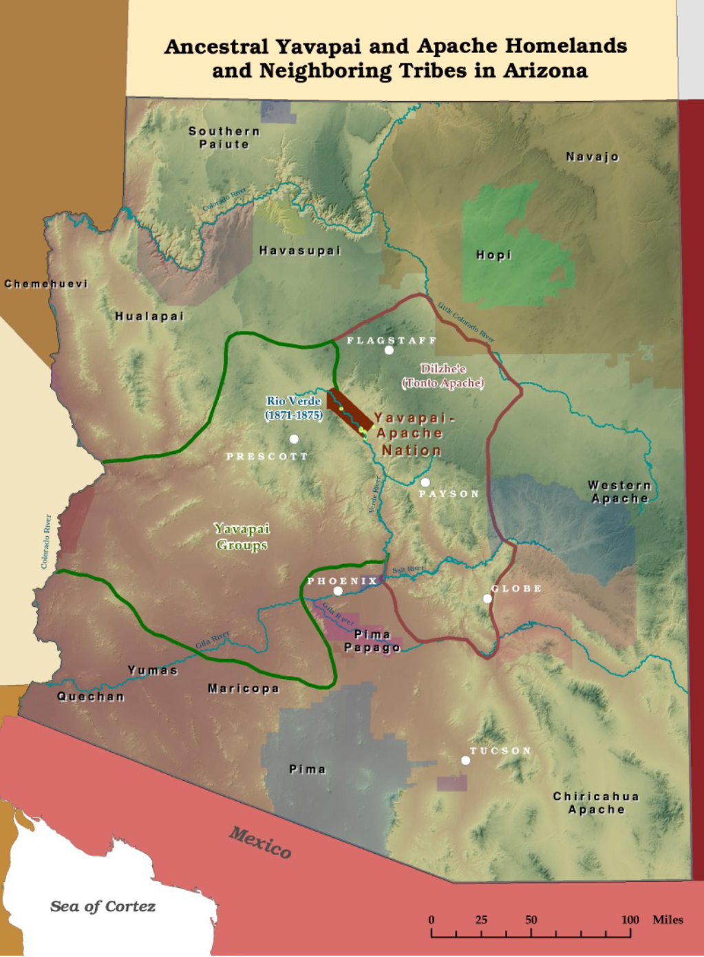
Before non-Indians arrived in the southwest, the homelands of the Yavapai and Apache people covered much of what is now central and western Arizona. (Map of Ancestral Yavapai and Apache Homelands and Neighboring Tribes in Arizona) By the mid-1800s, the Indian policy of the United States in the American West called for the concentration of Indian people on reservations and the opening of their ancestral lands to settlement by non-Indian miners, farmers, and ranchers.
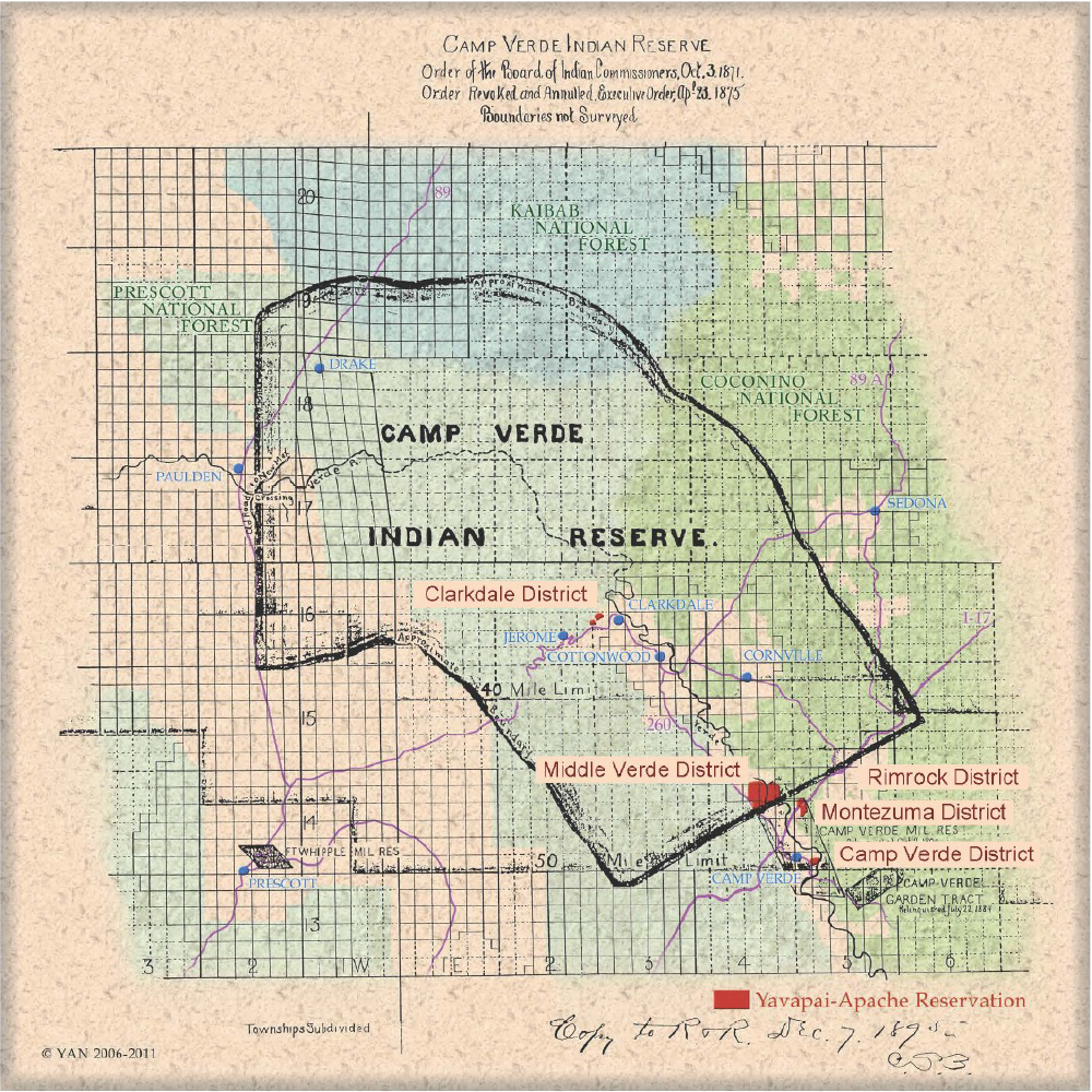
In 1871, the United States, acting by executive order through the Indian Commission, set aside from the much larger Yavapai and Apache ancestral homeland a 575,000-acre reservation for the Yavapai and Apache people. With the Verde River as its central feature, this large Reservation stretched throughout the Verde Valley and was 20 miles wide, 10 miles on each side of the River, for a distance of 45 miles. (Map of Camp Verde Indian Reservation 1871-1875) The United States intended the Reservation as a permanent homeland for the Yavapai and Apache. However, this permanency quickly gave way to the desires of local non-Indians for the Nation’s remaining lands and resources.
In February 1875, bowing to local non-Indian and Arizona Territorial political pressure, President Ulysses S. Grant directed local military officials to round up the Yavapai and Apache people on the Camp Verde Reservation and march them 200 miles in the dead of winter to the San Carlos Reservation. This amounted to the imprisonment of almost all of the Yavapai and Apache people living in the area that would last 30 years. In April 1875, President Grant revoked the 1871 executive order, dissolved the Camp Verde Reservation, and returned its lands to the public domain.
The Nation’s former reservation lands were opened to non-Indian settlement in 1877, and the Yavapai and Apache people lost their remaining lands and all they had. Forced from their homeland, they took only what possessions they could carry in their arms and on their backs. What was left of the Nation at that point was the lives of those who survived the forced march to San Carlos and the memories of the life they once had in the Verde Valley, held together by the bonds of family and the hope that someday they might be allowed to return to their homeland.
In losing their land, the lives of the Yavapai and Apache people were reduced by the United States to the lowest possible point of human existence. Day-to-day survival and an uncertain future replaced their prior peace and prosperity. By the early 1900s, the yearning to return to their Verde Valley homes was overwhelming. At the same time, there was a need for workers to help build Arizona’s new dams on the Verde and the Salt River systems. The Yavapai and Apache people were allowed to leave San Carlos to work on the dams, and eventually, they returned home to the Verde Valley in small family groups. When they returned home, however, they found their lands were fully occupied and “owned” by the non-Indian settlers who had originally called for their removal.
In 1909, the United States helped the Nation begin its long road to recovery with the acquisition in trust of a small 18-acre parcel in Camp Verde. In the 100-plus years since starting their return to the Verde Valley, the Yavapai-Apache people, with the help of the United States, have cobbled together a small Reservation of just over 1,800 acres, a small shadow of the 575,000 acres of their 1871 reservation and a still smaller fraction of their aboriginal homeland.
The extreme cultural, religious, social, political, and economic harm to the Yavapai-Apache people resulting from the complete loss of their homeland in the 1870s at the hands of the United States was immense. That loss and its traumatic harm have echoed through time from its inception to the present day. The recovery from that loss is slow but ongoing. This promise of eventual recovery is why the land exchange with the United States Forest Service is vitally important to the Yavapai-Apache Nation. The original harm wrought against the Nation under the failed policies of the United States cannot be erased, but it can be mitigated to a degree by the land exchange