
Johnston Ranch (Parcel 2)
143.96 acre parcel in Yavapai County, Arizona
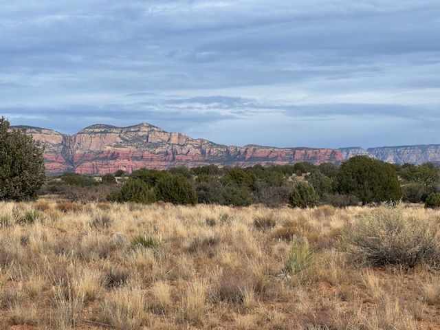
The historic Johnston Ranch Parcel is located between Sedona and Cottonwood in Yavapai County, Arizona. This 143.96 acre Parcel, more or less, is located north of State Route 89 about 20 miles west of Sedona. It offers views of the famous Sedona Red Rocks and Sycamore Canyon.
Johnston Ranch borders undeveloped private land at the northwest corner but is otherwise surrounded by the 1,856-million-acre Coconino National Forest.
Access to the property is from Forest Road 9548, which is a dirt road. A power line crosses onto the western side of the parcel from the north that used to serve an old well. The dry Coffee Creek runs through the property generally north to south. No water or electricity is available to the parcel.
Johnson Ranch is located in the heart of the old west historic cattle ranching country. Although not used for cattle grazing for some years, there are dilapidated remnants of its past offering a view of historic ranching life.
Historically private land touching National Forest land commands a premium. If this land is not added to the National Forest, the potential uses include, but are limited to, a subdivision, or a private compound. It could also be used for commercial purposes such as a corporate retreat, glamping operation, a training compound, or dude-ranch. Off-the-grid properties in remote areas offer extreme privacy and numerous opportunities for development/use. Unfortunately, in-holdings create numerous management challenges for the Forest Service, including fire and private access issues.
The Yavapai-Apache Nation acquired Johnston Ranch because of its natural beauty, wildlife, and it’s national forest surroundings. The Nation wishes to exchange this parcel to the Forest Service rather than develop it or sell it for development in order to contribute to the public benefit of the National Forest for all.
Making the Johnston Ranch Parcel a part of the National Forest will protect wildlife habitat, natural and aesthetic values, provide enhanced recreational values and public access to the Forest. It will also reduce burdens on the National Forest to manage its lands where the entire land unit is part of the Forest Service. Exchanging this parcel into ownership by the people of the United States is consistent with the Forest Management Plan.
Note: The County Assessor may show a different acreage, however the acreage used in this discussion is taken from the Forest Service data.