Cedar Ridge (NF 10)

118.92 acres made up of two non-contiguous “orphan” pieces of Coconino National Forest land
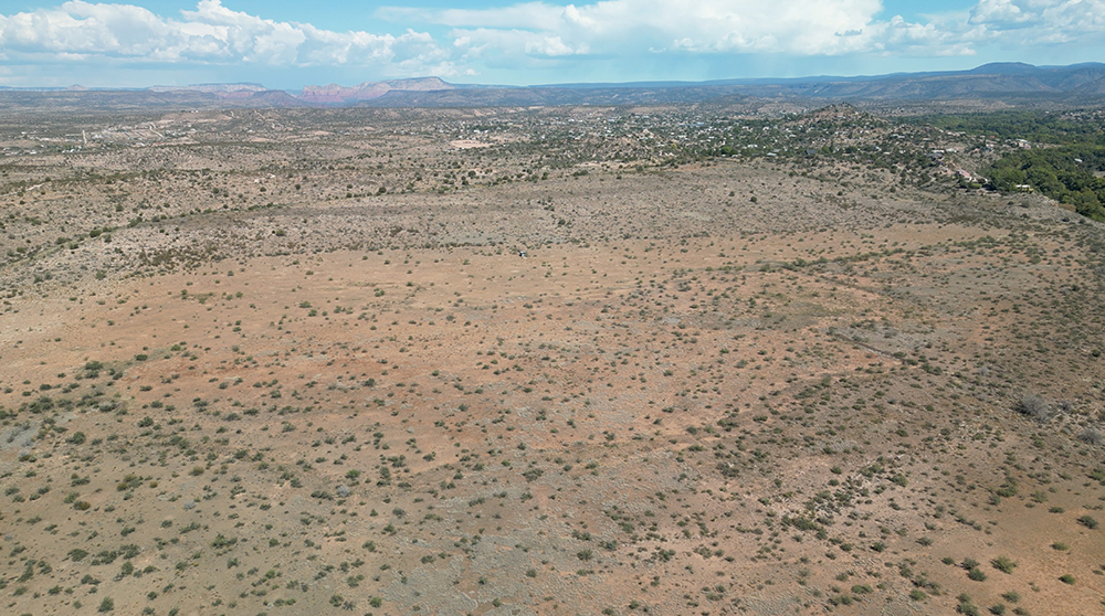
The Cedar Ridge Parcel (Map) is located in an unincorporated area in Yavapai County Arizona called Lake Montezuma. Lake Montezuma is a Census Designated Place which includes the communities of Rimrock and McGuireville. The area is typically called by any of those names. This rural community is surrounded by the 1.856 million-acre Coconino National Forest and located about 8 miles north of Camp Verde on the east side of Interstate 17.
The Cedar Ridge Parcel is made up of two non-contiguous “orphan” pieces of Coconino National Forest land and total 118.92 acres, more or less. Each piece that makes up the Cedar Ridge Parcel is surrounded by private land.
How did these parcels become orphans? The answer might be long lost to history, but there they are – two relatively small pieces of National Forest land surrounded by private land.
The western rectangular-shaped piece (West Piece) has the perennially flowing Wet Beaver Creek running through the land as well as Dry Beaver Creek. The square shaped easternmost piece (East Piece) has Wet Beaver Creek running through the very southeastern corner. The creeks result in a significant amount of floodplain, particularly on the western piece.
There has been significant growth in this community over the last decade. Although there have been a few residential subdivisions, most of the development has been “wildcat” where larger parcels are split, and sometimes split several more times for residential home sites. This type of development results in un-planned areas with often questionable legal access.
Typical in the area are custom homes or manufactured homes on acreage using private wells and septic systems. The County maintains the main roads, some of which are dirt. Private roads are also mainly dirt coming off of the main County roads. Typical of unincorporated areas there are fewer building restrictions than those found within the incorporated areas. Services are limited in this rural area.
Water Rights/Claims
There are no water rights claims associated with the Cedar Ridge Parcel. Likewise, there are no Statements of Claimant associated with the Property per the Arizona State Department of Water Resources.
Neither parcel has potable water or utilities available although there are utility rights-of-way running through the West Piece.
The West Piece
The West Piece is accessed from Brocket Ranch Road which turns into Dragonshead Road as it enters the property. Reay Road and Cross 2 Ranch Road (a.k.a. Culpepper Road) run through the property. Yavapai County maintains these roads providing both legal and physical access to Cedar Ridge West.
There are numerous residential ranchette type developments surrounding much of the West Piece. Neighbors have blazed their own illegal roads across this Forest Service land providing access to their private pieces. These blazed roads not only allow locals easier access across the West Piece, but visitors to the area as well. These encroachments have resulted in the destruction of natural habitat, aesthetics, and overall loss of forest character.
The East Piece
The East Piece does not have physical or legal access because it is surrounded by private land. The Forest Service staff have to ask permission from the surrounding private landowners to cross their land to get to this orphan property. The Yavapai-Apache Nation is one of the four adjoining landowners of the East Piece. However, these parcels will not become part of the Nation’s Reservation trust lands. The very southeast corner of the East Piece touches a pin-point of the northwest pin-point corner of a Forest Service parcel located to the southeast. However, that pin-point is in the Wet Beaver Creek and does not have a “butterfly” corner right-of-way with the adjoining landowners to allow legal access. Therefore, not only is it a challenge for the Forest Service to manage this land but the public cannot use it for recreation.
The West and East Pieces
These “orphan” pieces create difficult management issues for the Coconino National Forest. One piece has lost its forest character and the other cannot be used by the public.
Including the Cedar Ridge Parcel in the Yavapai-Apache Federal Land Exchange will alleviate significant management issues for the Forest Service. In the exchange the Forest Service will gain thousands of acres of beautiful land rich in native habitat and wildlife for the American people to enjoy.
