Lower 260 (NF 5)

1,726.19 acres located in the Prescott National Forest
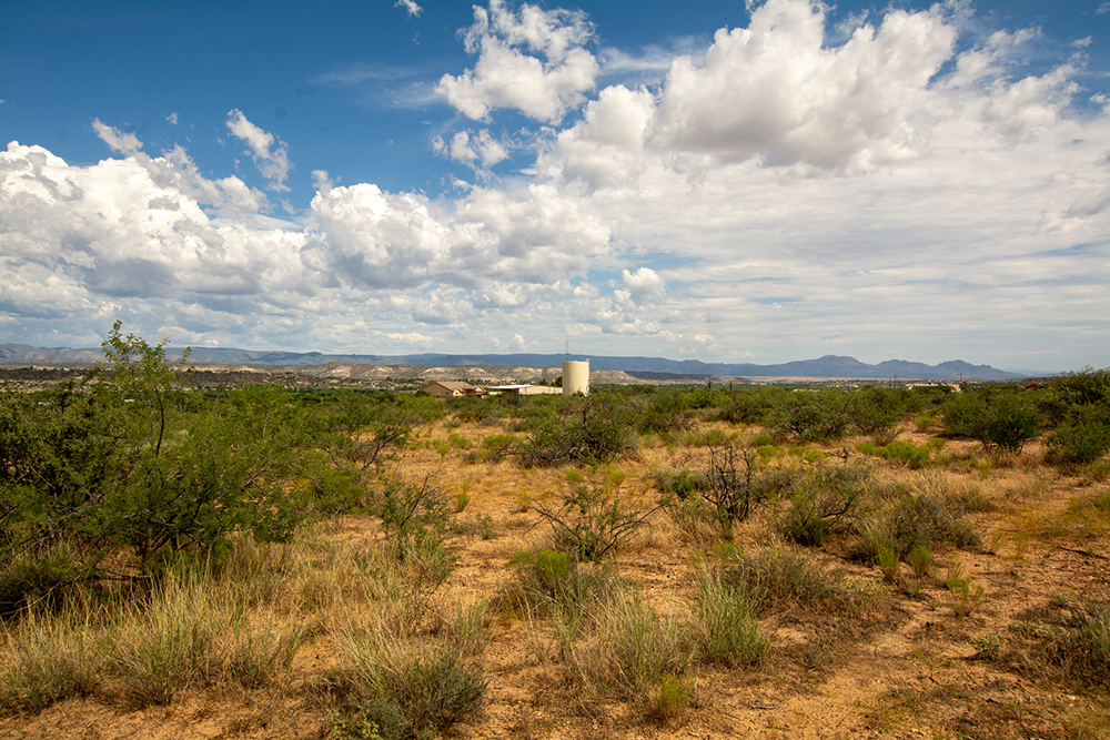
The Lower 260 Parcel (Map) is located in Yavapai County Arizona within the 1.25 million-acre Prescott National Forest and totals 1,726.19 acres, more or less. The Parcel is located within the municipal boundaries of the Town of Camp Verde Arizona (Town). The Town is located about an hour north of Phoenix and about an hour south of Flagstaff near the center of the state.
Interstate 17 (I-17) is a divided four-lane highway providing access from Phoenix through Camp Verde and north to Flagstaff. The Lower 260 Parcel is located on the northwest side of I-17 near where it intersects with State Route 260 (South of SR 260) and following SR 260 to its intersection with Cherry Road. SR 260 runs generally northwest from Camp Verde to the communities of Cottonwood and Clarkdale. The northern portion of the Parcel is bisected by SR 260.
The southernmost portion of the Lower 260 Parcel borders private land on its east side and national forest on its west side. The northernmost portion of the Parcel crosses over State Route Highway SR260 (SR260) several times and borders private land on its eastern border. The northwest side of the Parcel is bordered by private land and Prescott National Forest. The entire west side of the Parcel is bordered by Prescott National Forest. The southern boundary of the Parcel is formed by the northern boundary of the right-of-way for I-17.
The SR 260 corridor includes commercial, industrial, and residential developments as well as vacant land for future development.
Interstate 17 and State Route 260 Future
As reported by the Arizona Department of Transportation in its Average Annual Daily Traffic Report for 2022, Interstate I-17 had a 2022 estimated annual average daily traffic count along the stretch of highway from milepost 285.5 at General Crook Trail to milepost 287.3 where it meets State Route 260 of 14,682 vehicles per day. ADOT estimates that by 2042 the average daily traffic count traffic along this stretch of I-17 will reach 57,894 vehicles.
In this same 2022 report, ADOT indicates that between Cherry Creek Road at SR 260 and the Exit Ramp 287 onto I-17 the average annual daily traffic count is 7,252 vehicles per day. ADOT estimates that by 2042 the average daily traffic count along this stretch of SR 260 will be 25,307 vehicles per day. These traffic counts and projected traffic counts provide one indicator of expected growth.
Overall, the SR 260 corridor is desirable for future growth. However, despite its overlay zoning, there is a lack of sewer capacity restricting growth along the northwestern portion of the Lower 260 Parcel. This lack of infrastructure poses a serious challenge to future development and there is no resolution in the near future.
Camp Verde Town Boundary and General Plan
Although the Lower 260 Parcel is part of the Prescott National Forest, the Town of Camp Verde considers this land to be part of their community. Camp Verde not only includes it within the Town’s designated boundaries, but it also includes it in the Town’s General Plan. The Camp Verde General Plan has already designated the land for future development.
The Town of Camp Verde has named this Parcel part of the 260 West Character Area which is primarily undeveloped land. It is also known as the “Yavapai-Apache Nation/Camp Verde Economic Development Corridor.” The Town clearly anticipates this land being available for development in the future and fully supports the land exchange.
The 260 West Character Area includes residential, light, medium and heavy commercial, public facilities, agricultural, and industrial. Future preferred zoning includes agricultural, residential, commercial, industrial, mixed-use, natural resources, open space, and public facilities. The 260 Corridor also includes areas of active aggregate mining off of Old State Highway 279, with the Yavapai-Apache Nation owning the principal mining operation.
Access
There is no physical or legal highway access from Interstate 17 to this property. There are legal and physical access points onto the property along SR 260 including the following:
- State Highway 260
- Cherry Creek
- Newton Lane
- Verde West Drive
- West Horseshoe Bend Road
Forest Service Roads 9603R and 9603S traverse the property northeast to southwest allowing dirt road (high-clearance vehicle) access off of SR 260.
Water Rights/Claims
There are no Arizona Department of Water Rights registered wells associated with the property. Several washes cross this property. However, there are no surface water documents or surface water claims associated with the property. The Verde River crosses the very northeastern corner although there are no water rights/claims associated with the river.
Utilities
There are authorized buried utility and gas lines along SR260. There is also a 69kV electric transmission line crossing the property.
There is no sewer or developed water source available for development. Availability of electricity is unknown.
Authorized Uses
There is a buried natural gas transmission line and appurtenant features authorized on the site. Other authorized uses include a buried water transmission pipeline, fiber optic facilities, and telephone facilities. The buried water transmission line may be usable by this property. There is a 69kv electric transmission line crossing the property along with an electrical distribution line.
Cattle Grazing Permit
The southwest portion of the Lower 260 Parcel is part of the much larger Verde Grazing Allotment and about 1,526 acres of the Allotment are within the Parcel. The entirety of the Verde Grazing Allotment totals about 27,000 acres.
A Grazing Allotment Permit is not a lease. It is an authorized permit for a rancher to utilize a portion of National Forest land for their private livestock grazing. A term permit allows a rancher to utilize Forest Service lands for a specific period of time and is not automatically renewed.
The 1,526 acres of the larger Verde Grazing Allotment affected by this proposed land exchange equals only about 5.7 percent of the total permitted acreage of the Verde Grazing Allotment.
Unauthorized Uses
There is an unauthorized road known as Gray Hat (aka Cha Li Pah) on the west side of Highway 260.
There are unauthorized/non-permitted uses on the land including a road and a water diversion structure. The water diversion may in fact not be unauthorized because it may pre-date formation of the Prescott National Forest. The land would be conveyed to the Nation with these uses remaining in place.
Intergovernmental Agreement
In June 2022, the Town of Camp Verde (Town) and the Yavapai-Apache Nation entered into an Intergovernmental Agreement (IGA) to address, among other things, certain “land use, development, and in lieu of taxes issues” associated with the Nation’s acquisition of the Federal Parcels and their corresponding addition to the Yavapai-Apache Nation. The IGA describes how the acquired lands will be managed by the Nation upon completion of the exchange . The IGA also includes provisions addressing a tax-sharing arrangement between the Nation and the Town. This required a public process led by the town of Camp Verde for its community members and by the Nation for its community members. This formal agreement recognizes the significant benefits of the proposed exchange to both the Town and the Nation. Their lands being closely intertwined, the parties have established a cooperative and mutually respectful and beneficial relationship. Both the Town and the Nation wish to provide for the health and prosperity of their communities.
The Town recognizes that the Nation’s lands once spanned much of what is now the State of Arizona but now total less than three square miles, about 1,800 acres. The Nation has a young and growing population that requires more land. The Nation and Town negotiated an agreement to clarify the future relationship of the Parties regarding land use, development, and in lieu of taxes assuming the land exchange comes to fruition.
The Agreement spells out the Town’s interest in generating sales tax revenue through in lieu taxes. As mentioned, the Town has already identified the potential future lands in their 2016 General Plan and desires that any future development be consistent with their zoning standards.
The IGA spells out the agreements between the Nation and the Town on issues such as Traffic Analysis, Zoning, Building Standards, Fire District Inspections, Law Enforcement and Emergency Services, and established a Community Planning Group.
Summary
The urban-interface land that comprises the Lower 260 Parcel is currently used for cattle grazing by a local rancher who has the land fenced off. Given its proximity to major highways and commercial development it is not desirable for use by the public for recreation.
The Lower 260 Parcel is at the center of a growing, vibrant Town that supports development for the benefit of the population living within its Town boundaries. Despite the zoning the lack of sewer is a significant restriction on development and there is no solution for this problem in the near future. It may be years before the infrastructure is available.
This land exchange is essential to the common goals of both the Town of Camp Verde and the Nation in meeting the growing needs of their respective communities.
For more information on the Intergovernmental Agreement click here.
